Understanding geozone visits
Understand the details of how the locations recorded by the trackers are transformed in geozone visits.
How are geozone visits registered?
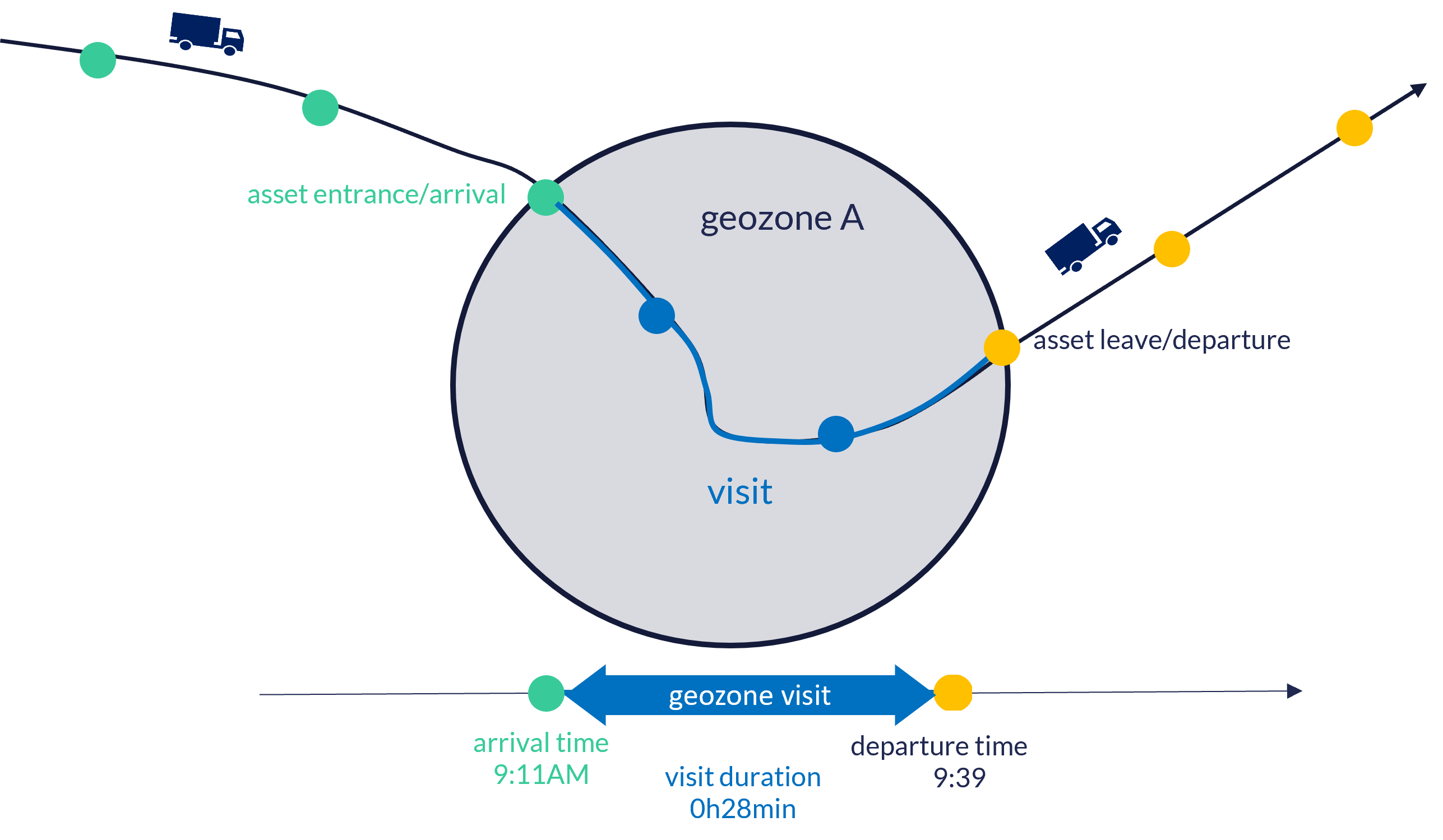
A geozone visit is the uninterrupted presence of an asset inside a geozone. The Sensolus platform will automatically calculate and register geozone visits for each geozone, and for each asset. A geozone visit of an individual asset starts when the asset enters the geozone, en stops when it exits the geozone.
The duration of a geozone visit is calculated as the time difference between the first registered localization inside the geozone and the first registered localization of the asset outside the same geozone. The figures below demonstrate how an asset geozone visit is registered.
It is important to understand that the accuracy of geozone visits is highly dependent on the localization accuracy and also frequency at which location updates are sent by the asset tracker. If fully accurate, real time location updates would be available, the duration of a geozone visit would be calculated as shown in the following diagram:
However, to optimize battery life, the amount of registered locations is limited when using low-power trackers, reducing the time accuracy. As a result, the start- and end-time registered in the Sensolus platform will deviate from to the actual entry or exit of the geozone. The extent of this deviation depends on the size of the geozone, tracker communication settings, etc...
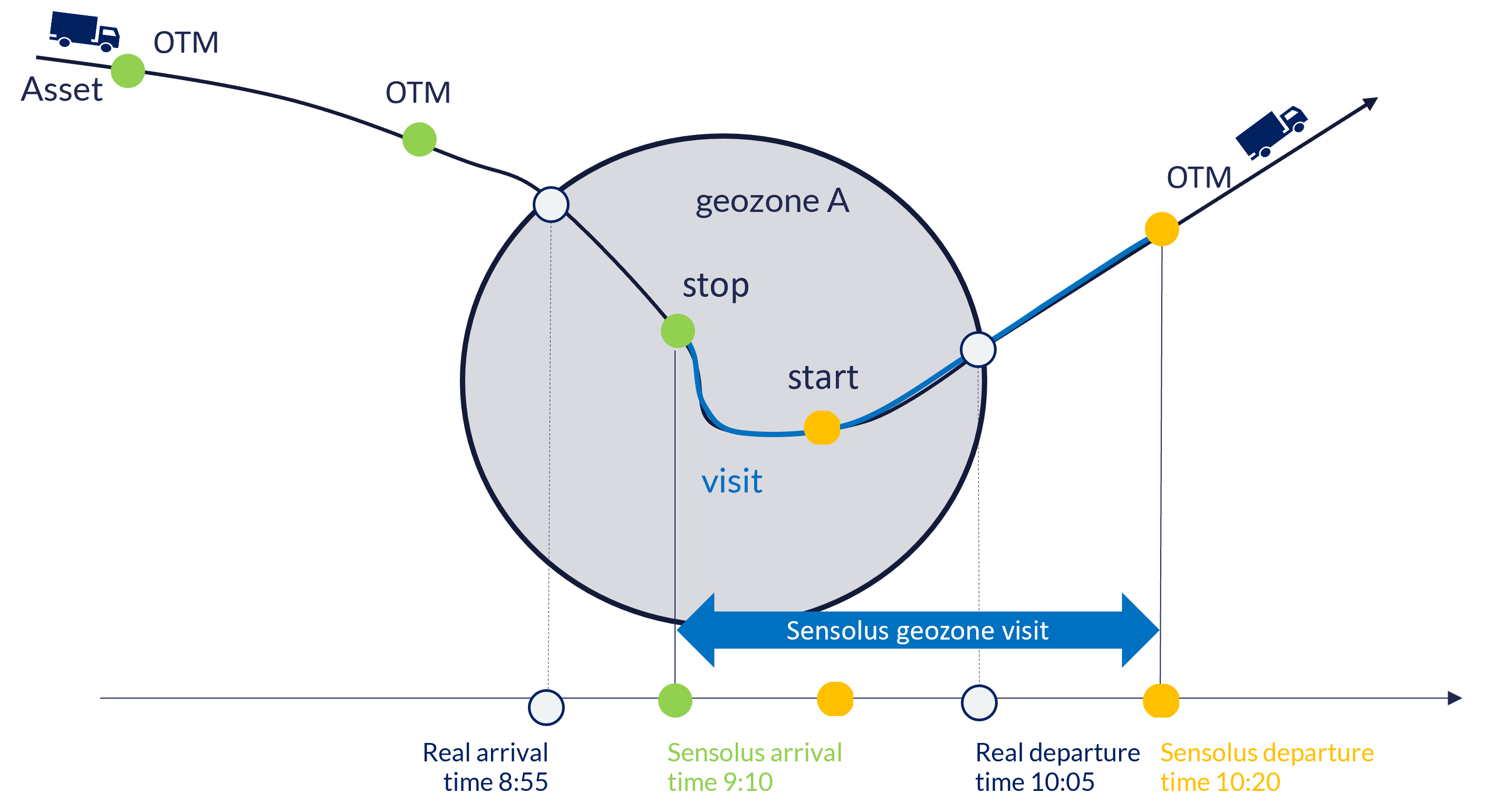
By default, network localizations are ignored for geozone visit evaluation, because of the low accuracy. This behavior can be changed in the settings of a geozone (option Network Location Matching in create or edit a geozone).
Geozone visits versus journeys
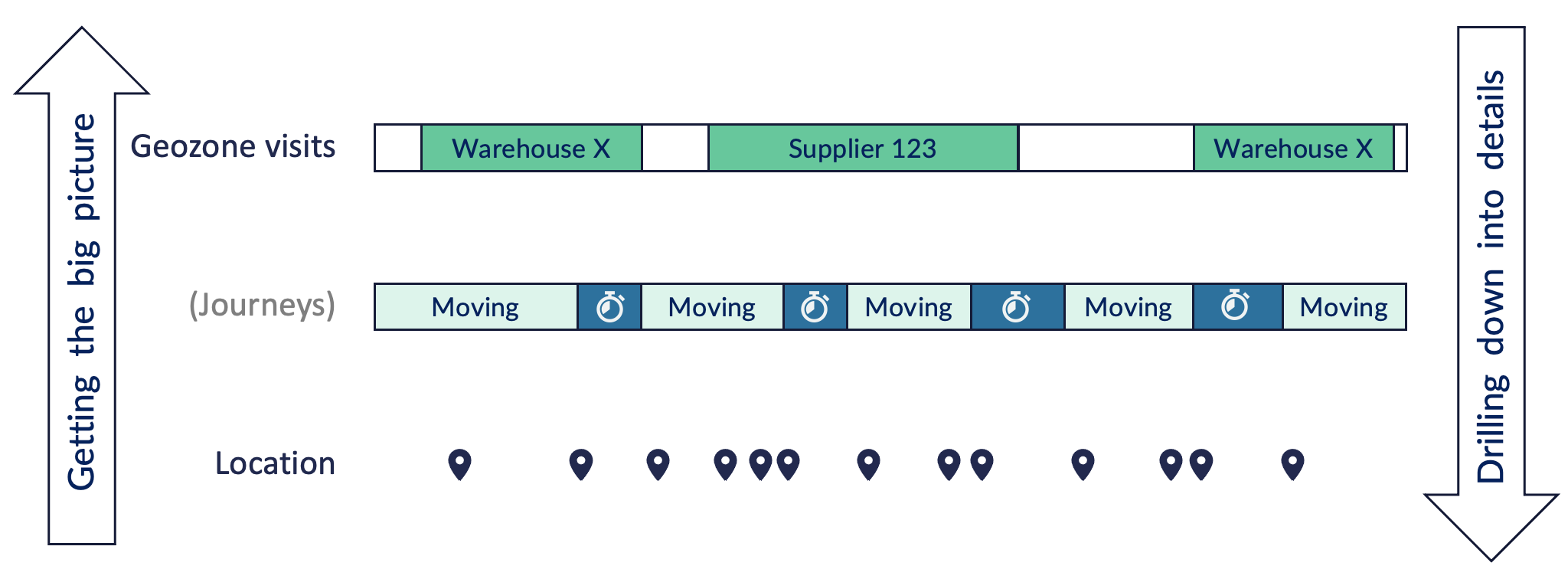
While journeys focus on capturing the full activity (=movements & stops) of an asset, geozone visits focus on the stay within a geozone and the transition between geozones. Movements inside the same geozone will be visible in journeys but are filtered out using geozone visits. Geozone visits allow to observe asset flows on a higher level.
The figure below visualizes the mapping between locations, journeys and geozone visits.
The table below summarizes the main differences between journeys and geozone visits:
| Journeys | Geozone visits | |
|---|---|---|
| When to use? |
If you are interested in getting insights into all the stops and trips of your asset. Typically used for drill down of trips of a specific tracker. Advantage is that it works out-of-the-box, without any configuration. |
If you are interested in aggregated insights regarding stays and movements between your zones of interest. |
| Timings |
Accurate stop times. |
Approximate visit times, strongly depending on the OTM rate for motion-based profiles and the update rate for periodic/scheduled profiles |
| Data pollution |
Multiple short stops in the same location result in a large number of registered stops, possibly cluttering the journey timeline. This can be solved by (1) tuning of the start trigger conditions and (2) aggregating stops at the same location. |
Inaccurate locations resulting in false ends of geozone visits. Could be solved by (1) making larger geozones and (2) defining minimum required accuracies for location that are used extracting geozone visits. |
| Compatible devices & configuration settings |
SNT X trackers configured with motion-based localization triggers. |
All trackers providing localization - irrespective of the vendor or usage profile. |
Overlapping geozones
The platform allows to create overlapping geozones. For example, an organization that operates internationally may want to create geozones for countries, in addition to having smaller geozones the represent industrial sites or warehouses.
In general, overlapping geozones are best used when modeling different hierarchical levels (for example: warehouses inside countries). In general it should be avoided to create overlapping geozones at the same level (for example: 2 warehouse geozones with overlapping would be confusing).
This means that from the perspective of the asset, an asset can be present in multiple geozones at the same time. A number of rules are used to display information for assets in multiple geozones:
Sometimes geozones are overlapping. For example, when having a big geozone covering a country and smaller ones inside that country. This results in overlapping geozone visits.
Following logic is applied to define next/previous geozone visit: take the next/previous geozone with the smallest time between entry/exit. If there are multiple visits ending/starting at the same time, select the one with the smallest area since this is probably the most meaningful one.